


Mapit GIS - Map Data Collector


Mapit GIS - Map Data Collector의 설명
Mapit은 현장에서 작업하는 동안 생산성을 향상 시키도록 설계된 전문적이고 독립형의 비용 효율적인 매핑 및 측량 도구입니다.
이 응용 프로그램은 입력 및 출력을위한 일반적인 파일 형식을 지원하며 필요한 경우 외부 미터 GNSS 수신기와 연동하여 센티미터 수준의 정확도를 얻을 수 있습니다.
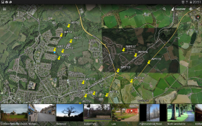
설문지를 디자인하고, 레이어에 데이터를 구성하고, mbtiles 기본 맵을 사용하여 오프라인으로 작업하고, WMS 서비스에 액세스하고, GPS 추적을 사용하여 회선 및 다각형 기능을 캡처하고, GNSS 메타 데이터를 기록하고 훨씬 더 많이 발견 할 수 있습니다.
이 앱은 전 세계의 전문가들에 의해 널리 사용되고 있으며 농업 및 임업에서 도로 건설, 지질학, 토지 측량 및 태양열 패널 솔루션에 이르기까지 다양한 응용 분야에 쉽게 적용될 수 있습니다. 개인화 된 설정 및 유연성으로이 응용 프로그램은 측량 작업 흐름을 향상시키는 용도 도구에 적합합니다.
앱은 지역 또는 거리를 계산하는 측정 도구로 사용할 수도 있습니다.
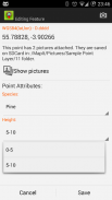
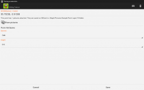
위치를 저장할 때 사전 정의 된 드롭 다운 목록에서 필수 속성을 선택하기 만하면 동일한 정보를 반복해서 입력하지 않아도됩니다. 텍스트 파일에서 긴 속성 목록을 가져 와서 프로젝트 수로 다시 사용하십시오. 필요한 경우 각 위치에 그림을 추가 할 수도 있습니다.
현장에서 작업하는 경우 많은 양의 공간 데이터를 수집하여이 앱이 설계되었습니다.
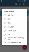
작업 흐름을 가속화하고 데이터 수집을보다 효율적으로 만듭니다. 여러 설문 조사에 대해 동일한 속성 집합을 재사용 할 수있는 설문 조사 레이어와 가능성을 활용하십시오. 데이터를 Esri shapefiles, CSV, KML, geojson, DXF, GPX와 같은 일반적인 GIS 형식으로 내보내고 qGIS와 같은 데스크탑 GIS 소프트웨어를 사용하여 데이터를 처리하십시오.
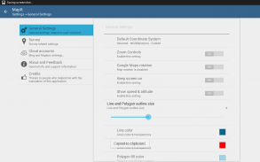
필요한 경우 사전 정의 된 좌표계 및 사용자 화 된 EPSG 코드 수 지원.
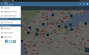
모바일 데이터 수집 기능 :
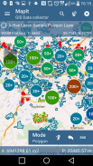
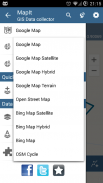
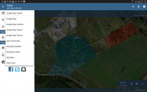
- 기본지도 : 인기있는 온라인지도 선택 및 오프라인 mbtiles,
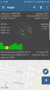
- 외부 블루투스 GPS / GNSS가 연결된 경우 RTK 보정 좌표 지원,
- WMS 및 GIS 서버 지원 타일 맵 서비스 - 지형 및 정사지도, 지질 조사, 지적 정보 및 기타 서비스의 수를로드합니다.
- 속성 집합을 생성하고 유지할 수 있습니다. 새로운 기능을 기록 할 때 드롭 다운 목록으로 사용할 수 있으며 긴 목록을 텍스트 파일에서 가져올 수 있습니다.
- 포인트 맵 마커 용 클러스터, 성능 문제없이 맵에 많은 수의 포인트를 갖는 효율적인 방법,
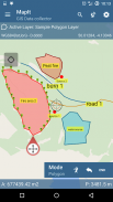
- 현재 4 가지 수집 방법이 지원됩니다 (GPS / GNSS 위치,지도 커서 위치, 추적, 각도 및 거리를 사용한 점 투영).
- 데이터를 측량 레이어로 그룹화 할 수 있습니다. 각 측량 레이어에는 기본 속성 세트가있을 수 있습니다.
- 로컬 SD 카드 또는 원격 내보내기. 현재 shapefile, KML, CSV, geojson, GPX 및 DXF 내보내기가 지원되며,
- Dropbox 또는 FTP 위치로 직접 내보내기
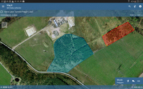
- 하나의 레이어에 여러 점, 선 및 다각형을 기록 할 수 있으며,
- 새로운 폴리곤이나 선 형상을 생성 할 때 면적이나 길이와 같은 측정 세부 사항도 사용할 수 있습니다.
- GPS / GNSS 및 위성 상태,
- 주소, 위치 검색,
- CSV, KML, shapefile 또는 geojson 파일에서 점, 선 및 다각형 피쳐를 레이어로 가져 오기,
- 백업 관리,
- 파일에서 속성 가져 오기 / 내보내기 및 훨씬 더 발견 ...
우리 사용자는 Mapit을 다음과 같은 응용 프로그램의 수에서 성공적으로 사용하고 있습니다.
- 환경 및 삼림 조사,
- 임업 계획 및 삼림 관리,
- 농업 및 토양 분류 및 샘플링,
- 도로 건설,
- 토지 측량,
- 솔라 패널 어플리케이션,
- 루핑 및 펜싱,
- 나무 조사,
- GPS 및 GNSS 측량,
- 사이트 측량
- 눈 제거
당사에 직접 연락하거나 웹 사이트의 문의 양식을 사용하는 것을 망설이지 마십시오.
Mapit GIS - Map Data Collector - 버전 7.8.0.0Core
(16-08-2021)

Mapit GIS - Map Data Collector - APK 정보
APK 버전: 7.8.0.0Core패키지: com.osedok.gisdatacollectorMapit GIS - Map Data Collector의 최신 버전
다른 버전들


동일 카테고리의 앱
좋아할 만한 것...
 3.614.414.154.213.4


